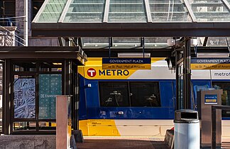
Government Plaza station
Light rail station in Minneapolis, Minnesota
GOVT51424(northbound/westbound)51409(southbound/eastbound)
 23.3%
23.3%| Preceding station | Following station | |||
|---|---|---|---|---|
| Nicollet Mall toward Target Field | Blue Line | U.S. Bank Stadium toward Mall of America | ||
| Green Line | U.S. Bank Stadium toward Saint Paul Union Depot | |||
Location | |
|---|---|
 |
Government Plaza station is a Metro light rail station on the Blue Line and Green Line in Minneapolis, Minnesota. The station is located on 5th Street South, between 3rd and 4th Avenues South in downtown Minneapolis. This station opened on June 26, 2004, with initial light rail service in the Twin Cities.
History and design

In 1905, Twin Cities Rapid Transit (TCRT) streetcars began running on new track down 5th Street from Hennepin Avenue to 4th Avenue in order to relieve congestion on the High Street Loop. In 1920, TCRT's flagship Interurban between Downtown Minneapolis and Downtown Saint Paul, streetcar predecessor to the Green Line, was rerouted down 5th Street from Washington Avenue via 5th Avenue. Streetcars continued this routing through downtown and were converted to buses on November 28, 1953.[3]
Fifth Avenue was converted to westward one-way traffic in the mid-1960s in conjunction with the construction of Interstate 94 and Interstate 35W. The westbound stop remained for Routes 16, a bus predecessor to the Green Line and replacement of the Interubran. Soon after the Metropolitan Transit Commission assumed TCRT's operations in 1970, the corridor would remain critical for westbound service from Saint Paul. In 1976 express bus service between downtowns was inaugurated along Interstate 94.[4] In June 1998 limited-stop Route 50 began operating, supplementing Route 16 during rush hours.[5] In order to compensate for the loss of westbound bus traffic on 5th Street at the beginning of light rail construction, a contraflow bus lane was placed one block north on 4th Street South. Construction of the downtown stations began summer 2002.[6] Service began at this station when the first phase of the Hiawatha Line, now the Blue Line, opened on June 26, 2004. Additional light rail service commenced June 14, 2014, with opening of the Green Line to Saint Paul.
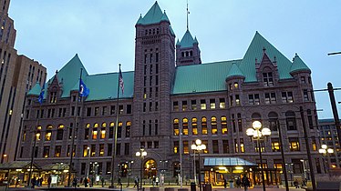
The station was designed by Barbour LaDouceur Architects, with Seitu Jones serving as architectural design team artist. In response to historic preservation concerns wanting to retain sightlines of Minneapolis City Hall from the adjacent street and plaza, particularly the Richardsonian Romanesque facade and arched entrance, the shelters at this station are spaced widely apart at each end of the long platforms.[6] Surrounding architecture influenced the station's design. For shelters, stone bases match that of City Hall's red granite and the canopies' exposed truss beam design was inspired by the nearby Milwaukee Road Depot train shed. Semicircular enclosures are oriented towards the direction of travel. Platform brickwork is continuous with the adjoining plaza.[7]
Side platforms extend into the sidewalk, closing off 5th Street to vehicle traffic. This is the only segment of the light rail along 5th Street with no vehicle traffic adjacent to the tracks. Government Plaza was the only downtown station that could not accommodate 3-car long trains, only being built for a maximum of 2-cars. The platform was lengthened from 200 feet (61 m) to 300 feet (91 m) the weekend of June 26, 2009.[8]
The Green Line Night Bus and rail replacement buses serve regular bus stops at 5th Street, the westbound stop is adjacent on 4th Avenue with the eastbound stop one block away on 5th Avenue.[9]
Public art

The public art installation, Local Connections: Minneapolis Views and Visions of Democracy, by Keith Christensen, features two granite columns roughly demarcating the boundary between the southbound platform and the plaza. The artwork also consists of eight printed images, two in each shelter, on two-sided panels of enameled glass. Images are either of different work gloves, solicited from community residents and workers, or aerial photography, historic and contemporary, of Minneapolis neighborhoods. The gloves allude to diverse population and democracy in work. Aerials contextualize how local activities fit into a larger scale. Phrases accompanying the columns and images pertain to community and civic engagement, and are translated into five languages common to Minneapolis: English, Spanish, Somali, Hmong, and Ojibwe.[10]
Small Kindness, Weather Permitting, by Janet Zweig, has four interactive boxes at the station: All the way around! #17, Ring the bell and see. #18, Go ahead and let it snow. #23, and Open the curtains please. #27.[11]
Notable places nearby
The station is surrounded by a high concentration of government buildings, suggestive of its name: Minneapolis City Hall, Hennepin County Government Center, Minneapolis Federal Courthouse, Hennepin County Public Safety Facility, and, most recently, Minneapolis Public Service Building. Directly adjoining the southbound platform is The People's Plaza. The Minneapolis Skyway System can be accessed from City Hall or Government Center, and a rare underground portion of the system runs beneath the station.
Landmarks nearby include CenturyLink Building, U.S. Bank Plaza, and Capella Tower.
Two and three blocks away are connections to the C Line and D Line at 7th–8th Street & 3rd/4th Avenue.
Gallery
-
 The light rail station with Occupy Minneapolis at The People's Plaza in the background.
 -
 Station lighting at dusk.
 -
 The station's design preserves the view of Minneapolis City Hall, an ornate Richardsonian Romanesque design.
 -
 Detail of a shelter.
 -
 Chalk graffiti on the platform during the Trial of Derek Chauvin in the murder of George Floyd.


See also
- Capitol/Rice Street, a Green Line light rail station in Saint Paul concentrated around the Minnesota State Capitol complex.
References
- ^ "Blue Line Station Maps". metrotransit.org. Metro Transit. Retrieved November 11, 2022.
- ^ "Transit Stops Boardings and Alightings - Minnesota Geospatial Commons". gisdata.mn.gov. Retrieved June 17, 2024.
- ^ Russell, Olson L. (1976). The Electric Railways of Minnesota. Hopkins, Minnesota: Minnesota Transportation Museum.
- ^ "Route 94: Saving time and money between the Twin Cities". metrotransit.org. Metro Transit. February 14, 2014. Retrieved November 11, 2022.
- ^ "Route 50: Limited stops for longer rides". metrotransit.org. Metro Transit. December 6, 2013. Retrieved November 11, 2022.
- ^ a b Reilly, Mark (February 24, 2002). "Stations connect city to rail". Minneapolis/St. Paul Business Journal. Archived from the original on November 11, 2022. Retrieved November 11, 2022.
- ^ Lovaasen, Jennifer. "Descriptions of Hiawatha Light-Rail Stations" (Press release). Hiawatha Project Office.
- ^ "Part of Hiawatha light-rail to shut down this weekend". MPR News. June 24, 2009. Archived from the original on November 11, 2022. Retrieved November 11, 2022.
- ^ "Rail Closures". metrotransit.org. Metro Transit. Retrieved November 11, 2022.
- ^ ""Local Connections"". metrotransit.org. Metro Transit. Archived from the original on November 11, 2022. Retrieved November 11, 2022.
- ^ "Government Plaza Station Public Art". metrotransit.org. Metro Transit. Archived from the original on November 11, 2022. Retrieved November 11, 2022.
External links
Wikimedia Commons has media related to Government Plaza (Metro Transit station).
- Metro Transit: Government Plaza Station Map
- Metro Transit: Government Plaza Station Public Art
- v
- t
- e
Minnesota Metro stations

- Target Field
- Warehouse District/Hennepin Avenue
- Nicollet Mall
- Government Plaza
- U.S. Bank Stadium
- Cedar–Riverside
- Franklin Avenue
- Lake Street/Midtown
- 38th Street
- 46th Street
- 50th Street/Minnehaha Park
- VA Medical Center
- Fort Snelling
- Terminal 1–Lindbergh
- Terminal 2–Humphrey
- American Boulevard
- Bloomington Central
- 30th Avenue
- Mall of America
- Target Field
- Warehouse District/Hennepin Avenue
- Nicollet Mall
- Government Plaza
- U.S. Bank Stadium
- West Bank
- East Bank
- Stadium Village
- Prospect Park
- Westgate
- Raymond Avenue
- Fairview Avenue
- Snelling Avenue
- Hamline Avenue
- Lexington Parkway
- Victoria Street
- Dale Street
- Western Avenue
- Capitol/Rice Street
- Robert Street
- 10th Street
- Central
- Union Depot

- Marquette-2nd Avenue & 3rd Street-Washington
- Marquette-2nd Avenue & 5th Street
- Marquette-2nd Avenue & 7th Street
- Marquette-2nd Avenue & 11th Street
- I-35W & Lake Street
- I-35W & 46th Street
- I-35W & 66th Street
- Knox & 76th Street
- Knox & American Boulevard
- I-35W & 98th Street station
- I-35W & Burnsville Parkway
- Burnsville Heart of the City
- Mall of America
- Cedar Grove
- 140th Street
- 147th Street
- Apple Valley Transit Center
- 46th Street
- 46th Street & Minnehaha
- 46th Street & 46th Avenue
- Ford & Woodlawn
- Ford & Finn
- Ford & Kenneth
- Ford & Fairview
- Snelling & Highland
- Snelling & Randolph
- Snelling & St. Clair
- Snelling & Grand
- Snelling & Dayton
- Snelling & University
- Snelling & Minnehaha
- Snelling & Hewitt
- Snelling & Como
- Snelling & Hoyt-Nebraska
- Snelling & Larpenteur
- Snelling & County Road B
- Rosedale Transit Center
- Brooklyn Center Transit Center
- Xerxes & 56th Avenue
- Brooklyn & 51st Avenue
- Penn & 43rd Avenue
- Penn & Dowling
- Penn & 36th Avenue
- Penn & Lowry
- Penn & 29th Avenue
- Penn & West Broadway
- Penn & Golden Valley
- Penn & Plymouth
- Olson & Penn
- Olson & Humboldt
- Olson & Bryant
- 7th Street & Olson/5th Avenue
- Ramp A/7th Street Transit Center
- 7th Street & Hennepin
- 7th-8th Street & Nicollet
- 7th-8th Street & 3rd/4th Avenue
- 7th-8th Street & Park
- Brooklyn Center Transit Center
- Xerxes & 56th Ave
- Brooklyn & 51st Ave
- 44th Ave & Penn
- 44th Ave & Girard
- Fremont & 42nd Ave
- Fremont & Dowling
- Fremont & 35th Ave
- Fremont/Emerson & Lowry
- Fremont/Emerson & 26th Ave
- Fremont/Emerson & West Broadway
- Fremont/Emerson & Plymouth
- 7th St & Bryant
- 7th St & Olson/5th Ave
- Ramp A/7th St Transit Center (southbound)
- 7th/8th St & Hennepin
- 7th/8th St & Nicollet
- 7th/8th St & 3rd/4th Ave
- 7th/8th St & Park
- Chicago & 14th St
- Chicago & Franklin
- Chicago & 24th St
- Chicago & 26th St
- Chicago-Lake Transit Center
- Chicago & 34th St
- Park-Portland & 38th St
- Chicago & 42nd St
- Chicago & 46th St
- Chicago & 48th St
- Chicago & 52nd St
- Chicago & 56th St
- Portland & 60th St
- Portland & 66th St
- Portland & 70th St
- Portland & 73rd St
- Portland & 77th St
- American & Chicago
- American & Bloomington
- American & Thunderbird
- Mall of America


