Gal Oya
River in Sri Lanka
| Gal | |
|---|---|
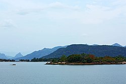 Gal Oya Dam in Gal Oya | |
| Location | |
| Country | Sri Lanka |
| Physical characteristics | |
| Source | |
| • elevation | 1,524 m (5,000 ft) |
| Mouth | Indian Ocean |
• location | Oluvil |
• coordinates | 07°18′01″N 81°51′54″E / 7.30028°N 81.86500°E / 7.30028; 81.86500 |
| Length | 108 km (67 mi) |
The Gal Oya is a 108 km (67 mi) long river, in southeast Sri Lanka. It is the 16th longest river in Sri Lanka.[1] It begins in the hills east of Badulla and flows northeast, emptying into the Indian Ocean south of Kalmunai.[2]
The river was dammed in 1948 as part of the Gal Oya scheme. The dam created the Senanayake Samudra — the largest reservoir in Sri Lanka, at Bintenne. Resettlement of the Tamils and Sinhalese people displaced in this scheme gave rise to among the first ethnic riots in Sri Lanka.[3]
The Gal Oya project resulted in the formation of the 100,000 acre Gal Oya basin. This basin has since been used for cultivating paddy, chillies, sugarcane and potatoes. The Gal Oya National Park in the vicinity has a wide variety of wildlife including bears, leopards and elephants. [4]
See also
- List of rivers in Sri Lanka
- Gal Oya Dam
- Gal Oya National Park
- Gal Oya riots
References
- ^ "The Gal Oya Legacy – Past and Present". The Pearl, Lanka. Archived from the original on 31 October 2016. Retrieved 5 August 2015.
- ^ Withanage, N.S. Morphometric Analysis of the Gal Oya River Basin Us ing Spatial Data Derived from GIS (PDF). Retrieved 5 August 2015.
- ^ Encyclopædia Britannica – Gal Oya River. Encyclopædia Britannica. Retrieved 5 August 2015.
- ^ Fernando, Srimal. "Gal Oya river and valley : an eye witness account". Srimal's Blog. Blogspot. Retrieved 5 August 2015.
- v
- t
- e
Inland waters of Sri Lanka
| ≥100km | |
|---|---|
| <100km |
|
- Abhaya Wewa
- Beira Lake
- Bolgoda Lake
- Diyawanna
- Giant's Tank
- Giritale Tank
- Iranamadu Tank
- Kala Wewa
- Kandalama Reservoir
- Kandy Lake
- Konduwattuwana Wewa
- Lake Gregory
- Minneriya Tank
- Muthuiyankaddu Kulam
- Nachchaduwa wewa
- Parakrama Samudra
- Ratgama Lake
- Sembuwatta Lake
- Sorabora Wewa
- Tissa Wewa (Anuradhapura)
- Tissa Wewa (Tissamaharama)
- Vavuni Kulam
| Eastern coast | |
|---|---|
| Western coast | |
| Southern coast |
reservoirs
| With hydroelectric capabilities | |
|---|---|
| Irrigation-only (incl. ancient tanks) |
|
Authority control databases | |
|---|---|
| International |
|
| National |
|


