Dürre Wand
Mountain ridge in Lower Austria
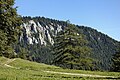
The Dürre Wand (literally barren wall) is a mountain ridge in Lower Austria and belongs topographically to the Gutenstein Alps. It stretches from Miesenbach in a WSW direction to the Schneeberg. The Dürre Wand is a ridge, rocky in places, which is bordered by pastures, forests and waterfalls. In contrast to Hohe Wand plateau in the immediate east, it culminates in a narrow ridge-line with its hiking trail offering outstanding views.
Elevations
The highest elevations are Katharinenschlag (1,222 m (AA)), Schober (1,213 m above sea level (AA)), Öhler (1,183 m above sea level (AA)) and Plattenstein (1,154 m above sea level (AA)).

Refuge huts
Located more or less central on the ridge, east of Öhler at a height of 1,027 m above sea level (AA), is the Öhler (Refuge) Hut which belongs to Friends of Nature (Naturfreunde). On Plattenstein sits the Gauermann Hut owned and run by the Austrian Tourist Club (Österreichischer Touristenklub) or ÖTK.
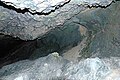
Caves
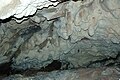
The Tabler Cave (Tablerhöhle, 1862/10)[1] east of the Plattenstein and the Erzloch (1862/4), a shaft cave east of the Öhler refuge hut, are two caves on the crest of the Dürre Wand. Other important caves are the Malepartuskluft (1862/19), Bergmilchkammer (1862/20), Marechle Cave (1862/21), Schichtkammer (1862/23) and the Vierpfeiler Cave (1862/24) (all in the Marecherkogel south of the Öhler near Puchberg am Schneeberg), the Zinsensteinhöhle (1862/11) and the Waldbodenloch (1862/61) (all in the north of the Dürre Wand near Gutenstein). In all, exactly one hundred caves are recorded in the register for Region 1862 - Dürre Wand.[2][3]
Gallery
-
 Plattenstein (1,154 m)
 -
 Gauermann Hut
 -
 Rescue shack next Gauermann Hut
 -
 The Öhler (1,183 m)
 -
 Öhler Rescue Hut
 -
 The Schober (1,213 m)
 -
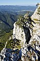
 View from the Plattenstein
 -
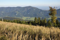 View from the Katharinenschlag (1,222 m)
 -
 Bergmilchkammer Cave
 -
 Malepartuskluft Cave
 -
 Marechle Cave
 -
 Schoberbachklamm Cave
 -
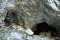 Lower Öhler Cave


Footnotes and references
- ^ The numbers after the cave names refer to the Austrian Cave Register (Österreichische Höhlenverzeichnis (ÖHV)) that in the state of Lower Austria are supported by the cadastral municipal societies:
Landesverein für Höhlenkunde in Wien und Niederösterreich,
Forschergruppe Neunkirchen des Landesvereins für Höhlenkunde in Wien und Niederösterreich,
Tauch- und Fahrtenclub Hannibal
sowie
„Höhlenkundliche Gruppe“ des Österreichischen Touristenklubs (ÖTK),
von der Karst- und höhlenkundlichen Abteilung des Verbandes Österreichischer Höhlenforscher geführt wird. - ^ Fink: Höhlen Niederösterreichs, passim as well as Hartmann: Höhlen Niederösterreichs, passim.
- ^ Höhlenkundliche Mitteilungen, passim.
External links
Wikimedia Commons has media related to Dürre Wand.
- Gauermann Hut (in German)
- Öhler Hut (in German)
| Authority control databases |
|
|---|
47°49′59″N 15°55′17″E / 47.83306°N 15.92139°E / 47.83306; 15.92139


