Chincha Province
13°27′S 76°08′W / 13.450°S 76.133°W / -13.450; -76.133
Province in Ica, Peru

Flag

Coat of arms
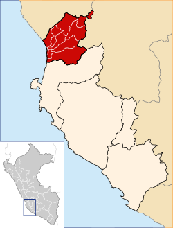
Location of Chincha in the Ica Region
(2019-2022)
(2005 census)
The Chincha Province is one of five provinces of the Ica Region of Peru. The capital of the province is the city of Chincha Alta, a center where the culture of the Black Peruvians developed. It is characterized by its schools and fabric textiles.
History
Geography
Boundaries
- North: Lima Region
- East: Huancavelica Region
- South: Pisco Province
- West: Pacific Ocean
Political division
The Chincha Province is divided into eleven districts (Spanish: distritos, singular: distrito), each of which is headed by a mayor (alcalde):
Districts
- Alto Larán
- Chavín
- Chincha Alta
- Chincha Baja
- El Carmen
- Grocio Prado
- Pueblo Nuevo
- San Juan de Yanac
- San Pedro de Huacarpana
- Sunampe
- Tambo de Mora
See also

Authority control databases | |
|---|---|
| International |
|
| National |
|
 | This Ica Region geography article is a stub. You can help Wikipedia by expanding it. |
- v
- t
- e


