Browncroft Historic District
Historic district in New York, United States
United States historic place
Browncroft Historic District | |
 One of the historic street signposts at the corner of Ramsey Park and Corwin Road | |
43°9′16″N 77°32′44″W / 43.15444°N 77.54556°W / 43.15444; -77.54556 | |
| Area | 116 acres (47 ha) |
|---|---|
| Built | 1914 - 1933 |
| Architect | Browncroft Realty Corp. (landscape), Gordon & Kaelber, et al. (homes) |
| Architectural style | Prairie Style, Tudor revival, Georgian revival, Colonial revival |
| NRHP reference No. | 04000346[1] |
| Added to NRHP | April 20, 2004 |
The Browncroft Historic District is a national historic district located in the Browncroft neighborhood of Rochester, New York. The district contains 518 contributing buildings, two contributing sites, two contributing objects, and two contributing structures over 116 acres.[1] It includes 417 residential properties constructed between 1914 and World War II.[2][3]
The neighborhood's original developer, Charles J. Brown, former president of the National Nurserymen's Association, gave it its name. It was declared a National Historic District and added to the National Register of Historic Places in 2004.[1][4] The district is "recognized for the architectural integrity of the homes, a landscape design that features uniform plantings of flowering shrubs and shade trees, and its role in the development of Rochester."[4]
Description
The historic district includes only certain designated properties located in a subsection of the neighborhood approximately circumscribed by Browncroft Boulevard on the North, Newcastle Road on the east, Blossom Road on the south, and Winton Road on the west.
Unofficial landmarks within the historic district include:
- Two of the development's original wrought iron street signposts (Located at the corner of Ramsey Park and Corwin Road (43°09′21″N 77°32′53″W / 43.155960°N 77.548040°W / 43.155960; -77.548040) and at the corner of Windemere and Newcastle Roads (43°09′19″N 77°32′31″W / 43.155360°N 77.541980°W / 43.155360; -77.541980)).
- The house at 273 Dorchester Road (43°09′15″N 77°32′34″W / 43.154210°N 77.542730°W / 43.154210; -77.542730) which contains columns from the original nursery office before its demolition.
- The house at 540 North Winton Road (43°09′21″N 77°32′57″W / 43.15577°N 77.54910°W / 43.15577; -77.54910), the original farmhouse of Steven M. Corwin,[5] which later served as Brown's home.
Gallery
-
 The Steven M. Corwin Home at 540 North Winton Road
 -
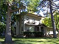
 10, 22 and 30 Ramsey Park
 -
 40 Ramsey Park
 -
 60 Ramsey Park
 -
 76-80 Ramsey Park


References
- ^ a b c "National Register Information System". National Register of Historic Places. National Park Service. March 13, 2009.
- ^ Browncroft Neighborhood Association. "Browncroft Historic District". Rochester, New York. Retrieved April 28, 2009.
- ^ Robert T. Englert (September 2003). "National Register of Historic Places Registration: Browncroft Historic District". New York State Office of Parks, Recreation and Historic Preservation. Retrieved May 14, 2011. See also: "Accompanying 40 photos".
- ^ a b "Browncroft earns place on historic register", Democrat and Chronicle, Rochester, New York, pp. 1B, May 4, 2004, ISSN 1088-5153, OCLC 5757784
- ^ Peck, William F. (1908), History of Rochester and Monroe county, New York, from the earliest historic times to the beginning of 1907, vol. 1, The Pioneer Publishing Company, p. 570, OCLC 3740785
External links
- National Register of Historic Places listing
- Landmark Society of Western New York neighborhood page
- District historic photos
- v
- t
- e
U.S. National Register of Historic Places in New York

by county
- Albany
- Allegany
- Bronx
- Broome
- Cattaraugus
- Cayuga
- Chautauqua
- Chemung
- Chenango
- Clinton
- Columbia
- Cortland
- Delaware
- Dutchess
- Erie
- Essex
- Franklin
- Fulton
- Genesee
- Greene
- Hamilton
- Herkimer
- Jefferson
- Kings (Brooklyn)
- Lewis
- Livingston
- Madison
- Monroe
- Montgomery
- Nassau
- New York (Manhattan)
- Niagara
- Oneida
- Onondaga
- Ontario
- Orange
- Orleans
- Oswego
- Otsego
- Putnam
- Queens
- Rensselaer
- Richmond (Staten Island)
- Rockland
- Saratoga
- Schenectady
- Schoharie
- Schuyler
- Seneca
- St. Lawrence
- Steuben
- Suffolk
- Sullivan
- Tioga
- Tompkins
- Ulster
- Warren
- Washington
- Wayne
- Westchester
- Wyoming
- Yates
by city
 Category
 List
List National Register of Historic Places Portal


