Brandenberg
Place in Tyrol, Austria

Coat of arms
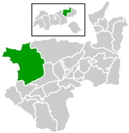
Location within Kufstein district
(2018-01-01)[2]
6234
tirol.gv.at
Brandenberg is a municipality in the Austrian state of Tyrol in the district Kufstein. It consists of the Brandenberg village and the Aschau locality (German: Ortsteil).
Brandenberg was first mentioned in 1140, and became an independent municipality in the beginning of the 19th century. The municipality is located in the valley of the Brandenberger Ache river, a tributary of the Inn River. To the north, it shares a border with Germany. Neighbouring Austrian and German municipalities are Achenkirch, Breitenbach am Inn, Kramsach, Kreuth, Rottach-Egern, Steinberg am Rofan, and Thiersee.
A local specialty is the Prügeltorte cake.
References
External links
- Website of the Brandenberg Tourist Board
Wikimedia Commons has media related to Brandenberg (Tirol).
- v
- t
- e
Municipalities in the district of Kufstein
- Alpbach
- Angath
- Angerberg
- Bad Häring
- Brandenberg
- Breitenbach am Inn
- Brixlegg
- Ebbs
- Ellmau
- Erl
- Kirchbichl
- Kramsach
- Kufstein
- Kundl
- Langkampfen
- Mariastein
- Münster
- Niederndorf
- Niederndorferberg
- Radfeld
- Rattenberg
- Reith im Alpbachtal
- Rettenschöss
- Scheffau am Wilden Kaiser
- Schwoich
- Söll
- Thiersee
- Walchsee
- Wildschönau
- Wörgl
Authority control databases | |
|---|---|
| International |
|
| National |
|
 | This Tyrol location article is a stub. You can help Wikipedia by expanding it. |
- v
- t
- e


