Boujdour Province
Province in Western Sahara
Boujdour إقليم بوجدور | |
|---|---|
Province | |
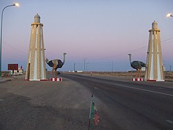 Route N1 at the exit from Boujdour town | |
 Flag | |
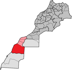 Boujdour (red) in Morocco / Western Sahara | |
| 26°08′N 14°30′W / 26.133°N 14.500°W / 26.133; -14.500 | |
| Country | Western Sahara |
| Seat | Boujdour |
Boujdour Province (Arabic: إقليم بوجدور) is a province in the Moroccan occupied region of Laâyoune-Sakia El Hamra, Western Sahara. Its population in 2004 was 46,129.[1] Its major town is Boujdour.[2]
Its territory, which is part of Western Sahara claimed by both Morocco and the Polisario Front, has been de facto administered by Morocco since the mid-1970s.
Location
The prefecture of Boujdour is located in the north of the region of Laâyoune-Sakia El Hamra. It covers an area of approximately 43,753 square kilometres (16,893 sq mi).
It is bordered by:
- Laâyoune and Es Semara provinces to the north
- Mauritania to the east
- Oued Ed-Dahab province to the south
- Atlantic Ocean to the west.
History
The province of Boujdour was created by the dahir establishing the law of 6 August 1976, after the Green March of 1975 leading to the Madrid agreements which divided Western Sahara in two. The Spanish region of Seguia el-Hamra was entrusted to Morocco while that of Río de Oro to Mauritania. Like the provinces of Laâyoune and Es Semara, the province of Boujdour was created on 6 August 1976.[3]
When it was created, the province of Boujdour had 2 circles which included 4 caïdats and the rural communes Bir Anzarane, Oum Dreyga, Boujdour and Gueltat Zemmour.[4]
Subdivisions
The province is divided administratively into the following:[5]
| Name | Geographic code | Type | Households | Population (2004) | Foreign population | Moroccan population | Notes |
|---|---|---|---|---|---|---|---|
| Boujdour | 121.01.01. | Municipality | 8416 | 36843 | 6 | 36837 | |
| Guelta Zemmur | 121.03.01. | Rural commune | 95 | 6740 | 24 | 6716 | |
| Jraifia | 121.03.03. | Rural commune | 380 | 1385 | 0 | 1385 | |
| Lamssid | 121.03.05. | Rural commune | 292 | 1161 | 0 | 1161 |
Population
In 2014 the population was 50,566, of which 42,651 were urban and 7,915 were rural.[6] The town of Boujdour had 42,651 inhabitants, Gueltat Zemmour had 6,383, Jraifa 950 and Lamssid 572.[6] Population growth:[7]
| 2014 | 2004 | 1994 | 1982 | |
|---|---|---|---|---|
| Total | 50,566 | 46,129 | 21,691 | 8,481 |
| Urban | 42,651 | 36,843 | 15,167 | 3,597 |
| Rural | 7,915 | 9,286 | 6,524 | 4,884 |
References
- ^ "World Gazetteer: Bū Jaydūr - profile of geographical entity including name variants". Archived from the original on 2013-02-09. Retrieved 2009-07-30.
- ^ "World Gazetteer: Bū Jaydūr - largest cities (Per geographical entity)". Archived from the original on 2013-02-10. Retrieved 2009-07-30.
- ^ Ouazzani Chahdi, Hassan (1986), "L'organisation administrative des provinces sahariennes", Georges Vedel présente : Édification d'un État moderne (in French), Albin Michel, p. 181, ISBN 2-226-02799-8
- ^ "Dahir 1-76-468 du 9 chabaane 1396 (6 August 1976) modifiant et complétant le dahir 1-59-351 du I joumada II 1379 (2 December 1959) relatif à la division administrative du Royaume" (PDF), Bulletin Officiel du Royaume du Maroc (3328): 915, 11 August 1976, retrieved 13 May 2014
- ^ "Recensement général de la population et de l'habitat de 2004" (PDF). Haut-commissariat au Plan, Lavieeco.com. Archived from the original (PDF) on 24 July 2012. Retrieved 27 April 2012.
- ^ a b Annuaire Statistique Regional, p. 7.
- ^ Annuaire Statistique Regional, p. 8.
Sources
- Annuaire Statistique Regional Laayoune - Sakia el Hamra (in French), Rotaume de Maric Haut-Commissariat au Plan, 2015, retrieved 2021-10-22
- v
- t
- e
Boujdour Province
Capital: Boujdour

- Aftissat (village, wind farm)
- Agti el Ghazi (village)
- Boujdour Lighthouse (lighthouse)
- Cape Bojador (cape)
- Côte Aftissate-Boujdour (Ramsar site)
- Zaouiat Ahmed Ben Yaddas (religious site)
| ||
|---|---|---|
Capital: Laâyoune | ||
| Provinces |
|  |
| Municipalities | ||
This Laâyoune-Sakia El Hamra location article is a stub. You can help Wikipedia by expanding it. |
- v
- t
- e


