Alsunga Municipality
Municipality of Latvia
Former municipality in Latvia
Alsunga Municipality Alsungas novads | |
|---|---|
Former municipality | |
 Coat of arms | |
 | |
| Country |  Latvia Latvia |
| Formed | 2009 |
| Centre | Alsunga |
| Government | |
| • Council Chair | Daiga Kalniņa (For The Growth of Alsunga Municipality) |
| Area | |
| • Total | 190.90 km2 (73.71 sq mi) |
| • Land | 186.31 km2 (71.93 sq mi) |
| • Water | 4.59 km2 (1.77 sq mi) |
| Population (2021)[2] | |
| • Total | 1,303 |
| • Density | 6.8/km2 (18/sq mi) |
| Website | www |
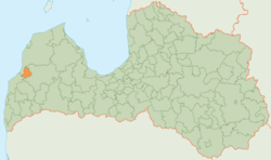
Alsunga Municipality (Latvian: Alsungas novads) is a former municipality in the historical region of Courland in Latvia. The municipality was formed in 2009 from Alsunga Parish, the administrative centre being Alsunga. The municipality consists of the following villages and settlements: Alsunga, Almāle, Balande, Dienvidstacija, Ziedlejas, Bērzkalni, Būcmaņi, Grāveri, Reģi.[3] As of 2020, the population was 1,268.[4]
On 1 July 2021, Alsunga Municipality ceased to exist and its territory was merged into Kuldīga Municipality as Alsunga Parish.[5]
See also
References
- ^ Error: Unable to display the reference properly. See the documentation for details.
- ^ Error: Unable to display the reference properly. See the documentation for details.
- ^ "Alsungas pagasts - Par Alsungu" (in Latvian). Alsunga Municipality. Archived from the original on 2010-08-04. Retrieved 2010-09-25.
- ^ "ISG020. Population number and its change by statistical region, city, town, 21 development centres and county". Central Statistical Bureau of Latvia. 2020-01-01. Retrieved 2021-02-12.
- ^ [1] Law on Administrative Territories and Populated Areas
- v
- t
- e
Former first-level administrative divisions of Latvia (2009–2021)

- Aglona
- Aizkraukle
- Aizpute
- Aknīste
- Aloja
- Alsunga
- Alūksne
- Amata
- Ape
- Auce
- Ādaži
- Babīte
- Baldone
- Baltinava
- Balvi
- Bauska
- Beverīna
- Brocēni
- Burtnieki
- Carnikava
- Cesvaine
- Cēsis
- Cibla
- Dagda
- Daugavpils
- Dobele
- Dundaga
- Durbe
- Engure
- Ērgļi
- Garkalne
- Grobiņa
- Gulbene
- Iecava
- Ikšķile
- Ilūkste
- Inčukalns
- Jaunjelgava
- Jaunpiebalga
- Jaunpils
- Jelgava
- Jēkabpils
- Kandava
- Kārsava
- Kocēni
- Koknese
- Krāslava
- Krimulda
- Krustpils
- Kuldīga
- Ķegums
- Ķekava
- Lielvārde
- Limbaži
- Līgatne
- Līvāni
- Lubāna
- Ludza
- Madona
- Mazsalaca
- Mālpils
- Mārupe
- Mērsrags
- Naukšēni
- Nereta
- Nīca
- Ogre
- Olaine
- Ozolnieki
- Pārgauja
- Pāvilosta
- Pļaviņas
- Preiļi
- Priekule
- Priekuļi
- Rauna
- Rēzekne
- Riebiņi
- Roja
- Ropaži
- Rucava
- Rugāji
- Rundāle
- Rūjiena
- Salacgrīva
- Sala
- Salaspils
- Saldus
- Saulkrasti
- Sēja
- Sigulda
- Skrīveri
- Skrunda
- Smiltene
- Stopiņi
- Strenči
- Talsi
- Tērvete
- Tukums
- Vaiņode
- Valka
- Varakļāni
- Vārkava
- Vecpiebalga
- Vecumnieki
- Ventspils
- Viesīte
- Viļaka
- Viļāni
- Zilupe
Authority control databases | |
|---|---|
| National |
|
| Geographic |
|
56°58′54″N 21°34′01″E / 56.98167°N 21.56694°E / 56.98167; 21.56694
 | This Courland location article is a stub. You can help Wikipedia by expanding it. |
- v
- t
- e


