Airport Road, Dhaka
| Tongi division Road | |
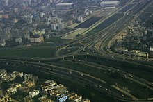
 Airport road at Uttara | |
| Former name(s) | Bir Uttam Ziaur Rahman Road |
|---|---|
| Part of | N3 |
| Maintained by | Dhaka North City Corporation |
| Length | 15 km (9.3 mi) |
| Location | Dhaka |
| South end | Bijoy Sarani |
| North end | Jashimuddin Avenue |
| Transport in Dhaka |
|---|
 |
| Streets |
|
| Roads |
| Bridges |
| Rail transport |
| Mass transit |
| Structures |
|
| Others |
|
|


Airport Road (Bengali: বিমানবন্দর সড়ক), also known as Tongi Diversion Road, a part of the Dhaka-Mymensingh Highway (N3), is an 8-lane major artery road in Dhaka, that connects Dhaka city, with the Shahjalal International Airport.[1] It is also the main artery that connects Dhaka with the northern suburb of Uttara and the only road that connects Dhaka with northern Districts of Bangladesh and vice versa.[2] Traffic is fairly smooth throughout the road, due to flyovers and interchanges.[3]
Facilities
Built as a highway to facilitate movement with northern districts of Bangladesh. The 8 lane highway (4 lanes on each side)[4] is one of the best maintained roads in Bangladesh,[5] It has a divider; however it doesn't have a shoulder for emergency and breakdown.
Landmarks


- Shahjalal International Airport
- Balaka Bhaban, Kurmitola
- Airport Railway Station
- Bangladesh Navy Headquarters
- Dhaka Cantonment
- Dhaka Cantonment railway station
- Radisson Blu Water Garden Hotel
- Best Western Dhaka
- Le Meridien Dhaka
- Dusit Thani Princess Dhaka
- Dhaka Regency
- Army Golf Club
- Bangladesh Golf Federation
- Heroes Live Forever Monument
- Nikunja 1 & 2 ( Joyar Shara Residential area)
References
- ^ "Airport Road, Dhaka". Google Maps. Retrieved 2011-12-14.
- ^ "Dhaka Photo Gallery by Brian McMorrow at". Pbase.com. Retrieved 2011-12-14.
- ^ Hafez Ahmed (2011-06-30). "Kuril flyover to be completed by next year". Daily Sun. Dhaka. Archived from the original on 2013-10-29. Retrieved 2011-12-14.
- ^ "Photo of Beautification of Airport road Dhaka, Bangladesh". Panoramio. 2008-05-06. Archived from the original on 2013-10-29. Retrieved 2011-12-14.
- ^ "Photo of Airport Road, Dhaka". Panoramio. Archived from the original on 2013-10-29. Retrieved 2011-12-14.
23°49′2.31″N 90°24′44.65″E / 23.8173083°N 90.4124028°E / 23.8173083; 90.4124028


