ACE Basin National Wildlife Refuge
United States National Wildlife Refuge in South Carolina
32°30′30″N 80°28′00″W / 32.50833°N 80.46667°W / 32.50833; -80.46667The Ernest F. Hollings ACE Basin National Wildlife Refuge is a 11,815-acre (47.81 km2) portion of the larger ACE Basin area, and the only portions that are federally protected. The wildlife refuge is divided into two units: the Edisto River unit and the Combahee River unit.
The following threatened or endangered species are present in the refuge: wood stork
External links
- Ernest F. Hollings ACE Basin NWR Website
![]() This article incorporates public domain material from websites or documents of the United States Fish and Wildlife Service.
This article incorporates public domain material from websites or documents of the United States Fish and Wildlife Service.
- v
- t
- e
Protected areas of South Carolina
| National Parks |
|
|---|---|
| National Historic Sites and Historical Parks | |
| National Military Parks and Battlefields |
|
| National Historic Trail | |
| National Forests | |
| National Wildlife Refuges |
|
| National Estuarine Research Reserves | |
| Wilderness Areas |
|
| Wild and Scenic River |
| State Parks |
|
|---|---|
| State Historic Sites | |
| State Forests |
|
| Heritage Preserves |
|
| Wildlife Management Areas |
|
| Seabird Sanctuaries |
|
The Lowcountry of South Carolina | ||
|---|---|---|
| Counties | 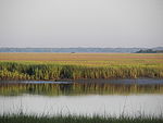 | |
| Major communities | ||
| Sea islands |
| |
| History & culture |
| |
| Military installations | ||
| Natural areas | ||
| Other articles |
| |
| Authority control databases |
|
|---|
This article related to a protected area in South Carolina is a stub. You can help Wikipedia by expanding it. |
- v
- t
- e


